Friday, April 07, 2006

Snakes!

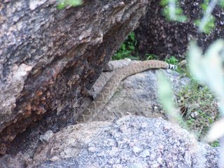
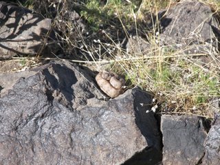
It's that time of year! I was hiking near Shaw Butte and made it to the summit of a little mountain. As I was walking along, I saw this snake curled up on a rock catching some rays. He was little, probably about a foot long. I wasn't sure what kind of snake it was until I got behind him and saw the distinct pit-viper shape of his head. He then removed all doubt when he started shaking his tail and chased me off. He actually followed me a few feet.

This isn't my first rattlesnake encounter on a hike. Last year while on Black Mountain in Carefree, I saw a huge rattlesnake, at least 6 feet long and maybe longer. The more I tell the story, the longer the snake gets. But it was no doubt huge. He didn't rattle at us, it was just sheer luck that I saw him slithering along. By the time I could whip my camera out, I could only get the last couple feet of him.

You know, hiking and nature is nice and all, but there's nothing quite like being within striking distance of a six foot rattlesnake to make you want to go home, turn on the A/C, plop down on the couch, and watch cable TV.

Monday, February 27, 2006

Granite Wash Petroglyphs

I was playing around on www.flicker.com and found photos by an interesting person who was driving around the South West developing mapping software. His photos are unique in that you can click a link and you'll see a map and coordinates of where the picture was taken. It sounds like a very cool feature for folks that want to include locations with their photos, and I'm sure it has many more applications that I can't even imagine.

I've been doing something similar (but on an elementary level) for some time now. It was killing me to write down coordinates everytime I took a picture, and taking a picture of the GPS screen after photographing a glyph wasn't exactly efficient either. So I thought to myself how cool it would be if I had a GPS that would record my location at various intervals. It was quite a task. Salespeople these days can do little more than read the side of the box to you when you want to know about an item's features. And the feature I was looking for just didn't seem that popular. I went through several high end GPS models before I found what I was looking for. I finally settled on a Garmin GPSmap 60C. This model allows you to record tracks based on time or distance intervals. So what I did was turn on the GPS and let it find the satellites to establish location and time. I imagine the GPS satellites are synchronized with a super-duper-accurate-atomic-clock or something. I then synchronize by computer's time to that of the GPS via a USB cable, then I would synchronize my camera's clock to my computer. It seems like the long way to do something, but now my camera and GPS are synchronized. Then I set my GPS to record my location every 30 seconds or so and turn it on at the beginning of a hike. Later I go home and download the recorded positions and photos onto my computer. Then if I ever want to know where a picture was taken, I can take the date and time from the pic, and compare it to the list of locations, and see the coordinates of where I took it.

There's software out there that will take all that info, and superimpose the coordinates on the picture for you, but it sells for something like two hundred bucks! No way! It's funny how I'll pay $450 for the GPS I want, $600 for the camera I want, but won't part with $200 to make my life a little easier!

I showed this neat little trick to some of the mouth-breathers at the AAS Rock Art Recording School. Some oooh-ed and awww-ed, some were indifferent, and others called me a heretic and threatened to burn me at the stake lest I steal their soul with my wizardry. I think it's important to point out that some of these folks were still wanting to record glyphs the old way, by photographing them on 35mm black and white film. I'm having less and less to do with the AAS these days in case you haven't guessed.

Sunday, February 12, 2006

Cave Creek

This is the cave at Cave Creek. Inside are petroglyphs, pictographs, and a firepit. The guide told us plenty of history about the cave, including a controversial massacre that took place there. Controversial massacre? Is there any other kind?
The cave is on private property owned by a trust organized to protect it. Once a month, six months out of the year, volunteers take groups of up to 30 people to see the cave. So I feel kinda special because there are very few people that have actually seen the cave at Cave Creek.
The trust I mentioned has a website of course. Here it is...
http://www.dflt.org/index.htm


Sunday, February 05, 2006

Hayden Butte

I hiked up Hayden Butte in Tempe today to see the glyphs. It was a good little hike, nothing strenuous, just enough to get the blood pumping. The view from the top was nice and you could see a great view of the Tempe Town Lake.
Plenty of glyphs, mostly abstracts. But there were a few anthromorphs and quadripeds. I had to go off the trail past the signs that said "Please Stay on the Trail" to get most of the good pics. I believe in good natured tresspassing, and I'm not afraid to hop a rail or climb a fence. In fact, if it weren't for a couple of good natured tresspassers, we wouldn't have those fantastic Kartchner Caverns down by Benson.

Here's an interesting pair. They look identical and stand side by side, they may be twins. Hero or Warrior Twins figure heavily in South West and Meso American mythologies. The Navajo call them Monster Slayer and Born for Water. In the Mayan Popol Vuh, twins grow and defeat the gods of the Underworld.
These figures might represent them, they might not. But it's fun to speculate, to put yourself high on that hill a thousand years ago, and try to get into the mind of the person who etched these figures.

Sunday, January 29, 2006

Polly Schaafsma

Over the weekend, the kids and I went to Flagstaff to see a speaker at the Museum of Northern Arizona. Here's their website...

http://www.musnaz.org

The speaker was part of their Stories on Stone presentation, a petroglyph exhibit. It focuses on the Colorado Plateau, so there's none of the Hohokam glyphs that I'm accustomed to.
Back to the speaker. Dr Polly Schaafsma is basically the Stephen Hawking of the field of petroglyph study. Back in the 60's when petroglyphs were largely regarded as graffiti, she took note of them and developed the field of study they are today.
It was an interesting presentation. The only problem was the Q&A afterwards. Because the field of petroglyph study isn't that popular, the audience was made up of mainly glyph nerds and wanna-be archaeology types. They were happy to argue points that they thought were valid, and ponder the imponderable. Some of the questions were just unreasonable, and should have been posed to the people that actually made the glyphs. I thought to myself that they should all go home and pray over some crystals or something!

Sunday, January 22, 2006

Somebody screwed with my Glyph Site!!

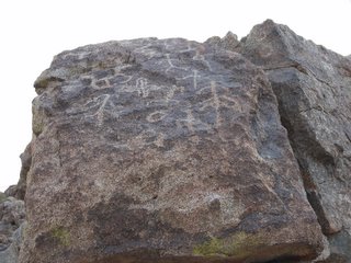
Somebody fucked with my glyph site!! Ok, maybe I should just relax, and take a deep breath. Behold the picture on the left, taken on November 6th of 2004. I think this pic may appear earlier in my blog. The whole mountain that these boulders rest on had been so heavily disturbed, so it's impossible to tell what direction these originally faced. In fact, the top portion of this boulder is missing. It probably has a bunch of cool glyphs on it, and it's probably a decoration in someone's back yard.


Now here's a pic of the same glyph site today (January 22nd, 2006). Somebody messed with it. I mean, it's not my glyph site. But it's the first glyph site I ever found, so naturally I feel a connection to it. Some jackass picked up a boulder and put it on top of the other boulder. Ok, I can't describe the scene well, but that's what pictures are for.

So, what amI gonna do? Well, I'm not gonna be the Glyph Nazi and call 911 or anything. But I will send these before-and-after pics to the city archaeologist in hopes that they can toss it in the huge 'in box' that they don't have the time or funds to address.

Monday, January 16, 2006

Montezuma's Castle

Since I'm still a little gun-shy about going to remote glyph sites (see previous post), I decided to see something touristy and well paved. Montezuma's Castle came to mind, so off I went.
This is very interesting, and falls within the 'amazing feats of neolithic construction' category. It's basically a fort built into a cliff face. As you stand there looking at it, you don't see any stairs, steps, or a path leading up to it. Maybe the same aliens that helped build the pyramids came over and helped the Sinagua with this little defensive position.
It's managed by the National Park Service, and it's only $3 to get in. Check it out...

http://www.nps.gov/moca/

Tuesday, December 20, 2005

Sears Point Petroglyphs

I went to Sears Point yesterday to see the petroglyphs. Very nice, and a bit of a challenge to get to. I wouldn't try this trip during monsoon season. As I lack a 4WD vehicle, I went in my Chevy Malibu. The sand was a little soft in a couple areas, but nothing that worried me. I did however decide to take a 'shortcut' back to the freeway.
A shortcut can be a little like a drinking binge. You barely survive it and afterwards promise to never do it again. Until the next time of course. The road looked OK on the mapping software, but the sand was really soft and I bottomed out in a few places. Bottoming out of course brought vivid memories of cracking my oil pan on that trip back in June. And we were out in the sticks. Forget a tow truck, we would have needed a helicopter to get out of the spot we were in if we got stuck. I'm just gonna have to break down and get myself a 4WD early next year. Otherwise you might see me on the evening news.

Like I said, the glyphs were great. This place kind of threw me for a loop because there was a heavy concentration of glyphs on the north side of the mountain. Usually you find glyphs on east and west sides as they often interact with the sun.
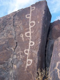
I have no idea what this image means, but there were about half a dozen glyphs with this theme. On top of the mountain (I think it was actually a mesa) there was a rock formation that represented this style of petroglyph.

Tuesday, October 18, 2005

Rock Art Recording Field School

I got back from my Rock Art recording trip last night. I came home early because of some drama with my ex. I half expected something like this to happen, she always finds a way to screw up anything I might do for myself.
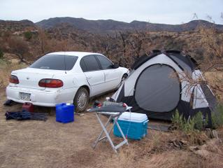
Here's where I set up camp. People were surprised that I was able to maneuver my Chevy to the camp site. Everyone else has trucks, jeeps, 4x4's, etc. One couple brought out their RV. You know, maybe this is my age talking, but RV's look better to me all the time, especially when it comes to little camping trips like this. Waterproof, built it toilet and shower, actual bedding, all the comforts of home. When I went to Burning Man a few years back, I noticed that some folks brought RV's and I have to admit I was jealous.
Of course, I believe that I'm being a hard core camper when I pitch a tent and crawl into a sleeping bag. I feel like I'm priveledged if I pump up an air mattress to sleep on.
But you know what? Screw all this 'roughing it' crap! I think my next camping trip will be a nice room on the 25th floor of a Vegas hotel overlooking the Strip.
And since I'm in a 'screw it' state of mind right now, here's an interesting story. One night during the trip, we were all sitting around being self important, speaking highly of ourselves and our mission, when one person asked "What's the point?" It seems that the Forest Ranger was out to see us, and someone played devil's advocate and questioned the significance of archaeology. At first, some people became defensive as they were convinced that we were performing an important service. But as the question sank in, I had to ask myself...on a grand scale, who gives a shit? Not too many people obviously. No one is making a living studying petroglyphs. I'm sure there are some honest-to-God archaeologists on staff somewhere who include petroglyphs in their studies, but they no doubt have bigger priorities and ever shrinking budgets. The Forest Ranger I mentioned earlier? He's the ONLY ranger for a 3 million acre chunk of land. Someone could go out there and destroy glyphs and ruins at will, and he'd be ill equipped to do much about it. If there was any major damage done, it sure wouldn't make the front page of the newspaper.
Maybe I'm just glyphed-out from the trip, maybe I need a little time off, or at least a nap. But as I went through all the steps of recording rock art, I had this very uneasy feeling that after all this was done, the reports would end up in a box in a room somewhere, and promptly forgotten.

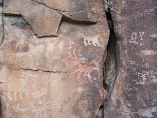
Ok, enough whining. There were hundreds of glyphs. Some where redundant, others were very unique. Here's an example of something I haven't seen before. There's a deer-type creature, and it's painted red. Colored petroglyphs aren't exactly unique, and there are examples of them all over the world. In fact, most were probably colored at one point, but faded due to time and erosion. This is a big deal for me because it's the first colored glyph that I've seen in person. There was a red lizard too, but I like this one because it's in the area that I was working.

Wednesday, October 05, 2005

Ehrenberg Revisited, White Tanks Petroglyphs

In the previous post, I showed a pic of a cemetary monument in Ehrenberg that had a boulder with glyphs on it. I was pretty content with myself for having noticed, and was ready to play the advocate and scold the guilty parties for their criminal act.
Well, I made some phone calls and talked to one of the locals. That monument is decades old, and if I want to talk to anyone who was involved in the construction, I was going to need a shovel because I'd have to dig them up first. The local I spoke to said that he'd be surprised to see glyphs on the monument because at the time of construction, Indian/Settler relations weren't so hot, so it would be unlikely that the deceased would be honored with decorations made by local Indians.
That being said, I think I'll let this one slide. I'm sure I'll find some other windmill to charge later on.

So I signed up for a class with the AAS. It's called Rock Art Recording. It involves actual classroom instruction on Monday nights, and a week camping out in the field recording glyphs in the Tonto National Forest. A week camping, wow. And that's not even a vacation. My kids are gonna be pissed when they hear I spent a week in the woods and didn't bring them along.

It seems to me that the folks that are taking this class must have a lot of time on their hands. One night a week for 3 and a half hours? No problem. A week out in the woods? Uhhh...that's gonna sting just a little bit. But these little side trips? That's too much. It seems that in addition to class, we're supposed to have these little field trips. Last Sunday we met at White Tanks Park. We were supposed to be there at 8am. I get off work at 7:30am if I'm lucky, then had to haul my butt from work to White Tanks to get there just in time for the petroglyph hike. Of course I had just worked 3 nights in a row, so I was tired and still wearing scrubs.
Showing up in scrubs presented another problem. When asked earlier what I did for a living, I was vague in my response. I'm proud of my job, my title, and the work I do, but sometimes I don't want to walk into a group of people I just met and announce that I'm a RN. I'm sure anyone in my profession understands my point. It's almost inevetable that once people find out what you do, someone drops their pants, shows you a part of their body that rarely sees the light of day, points to something, then ask "Is that a pimple or a boil?" If something goes wrong, I'll jump in and do what I can to help, but I kinda wanted to put this off for a bit.
Well, it wasn't but a few minutes before everyone knew what I did for a living. At the next meeting (which I was late to), the instructor informed the group that I would be their "Red Cross person" in the event of some kind of emergency during the camping trip. Yes, I was asked first, and yes, I agreed. But what was I going to do, refuse?

On to the White Tank glyphs. My daughter and I went on that exact same hike and saw the same glyphs back in March. I should've just went home and got some sleep. There were a couple of ladies who were very knowledgeable about the site and had devoted years to recording glyphs in the area. Some of my fellow students asked a lot of questions. Questions are good, but I find sometimes that if you let a person finish what they're saying, they end up answering your question for you.
One man insisted that this is a glyph of a palm tree. Never mind that palm trees aren't native to Arizona, never mind that it looks more like a corn stalk, and never mind that it's well established that the tribes in this area grew squash, beans, oh and CORN!

Here, check this out. Water and corn. I shouldn't act like I'm so sure about this, because I feel most of this stuff defies interpretation. But one thing that I'm pretty sure of is that these aren't palm trees!
Sunday, September 25, 2005

Beautiful Downtown Metropolitan Ehrenberg

Ehrenberg, Arizona. It's a little gas station town where I10 crosses the Colorado River. It has a nice truck stop where you can get gas a whole lot cheaper than in California. When I was a kid my grandparents would take me with them to Ehrenberg to buy lottery tickets, because back then California didn't have a state lottery. In Ehrenberg there's a little cemetary, a 'boot hill' if you like. It's a historical landmark now.

Take a closer look at the rock on top of the tower. It has glyphs on it! I figure some well meaning soul thought it would make a great pinnacle to a great monument.
Before I go on a witch hunt here, I think I'll make a few phone calls and find out if there wasn't some type of exemption or special circumstance that permitted this. If not, I hope to make this an example of 'what not to do.' I'm certainly not going to ask anyone to take it down.
Of course, I could just be spinning my wheels. Maybe someone else has already tackled this issue and an agreement already met. I'll post updates here on my blog.

Tuesday, September 13, 2005

V Bar V Petroglyphs

Ok, someone suggested that it was a cop out not to post a photo of the glyphs at V Bar V site, so here's one. The site is pretty interesting. If you look at the glyphs closer to the ground, you can see that they're pretty dense in number, many are right on top of eachother. Higher up are the more distinct glyphs. The guide at the site pointed out that the creek that ran nearby would flood out occasionally and deposit soil up against the glyph panel. There was evidence of an archaeological dig, and it's said that there are glyphs on the panel that are as much as four feet underground. So at one point, these glyphs were as much as 12 feet above ground. Not bad for a group of people that were estimated to be about five feet tall.

Saturday, September 10, 2005

Beaver Creek

This is Beaver Creek. Actually it's Wet Beaver Creek as there is a Dry Beaver Creek nearby. So let's recap...this is Wet Beaver Creek. The frat boy in me is just dying to take this and run with it! But I'll opt for a little maturity and just share this great pic instead.
Just a mile away is the V-Bar-V petroglyph site. Pretty nice, and there was a really helpful volunteer who gave a little history about the site and the preservation effort. He even described what was believed to be a birthing site nearby. Even gave me enough vague directions as to where it was. Shouldn't tempt me like that! Hell, a sure fire way to get me to go somewhere is to tell me to stay away! It seems to me that the people who hold my leash would exploit that quality of mine, but they never do.
I'd put a pic up of the glyphs, but they're probably the most photographed in Arizona, so I'll spare you.

Tuesday, August 23, 2005

Wow, betcha didn't know about this.

Here's something you don't see everyday. This is an Aerostat blimp operated by the USAF. There are about eight of them along the southern border of the US, all equipped with radar and probably a few of those cameras that can count the dimples on a golf ball. They're used by many agencies, but mostly by Customs to help fight the war on drugs. It seems that in the old days, it was pretty easy to fill up your Cessna with a ton of reefer and fly it to a remote desert landing strip where you could unload it and not have to deal with that whole border crossing smuggling thing. Then these blimps came along and changed all that. I'm sure they do a whole lot more than catch planes on radar as they can carry payloads of about 1200 pounds.
Yeah, the picture isn't that great. But while it looks like it's just over those trees, it's actually pretty far away. That means this blimp is a lot bigger than it looks in the picture. According to the fact sheet, it's roughly twice the size of the Goodyear Blimp. Maybe it's because I haven't seen the Goodyear Blimp since I was a kid, but that seems pretty big to me.
You can check this website for more info about the blimp...

http://www2.acc.af.mil/library/factsheets/tars.html

This one is just north of Yuma, Arizona. I've seen the ones above Fort Huachuca in Arizona and Deming, New Mexico. I've seen the Yuma blimp several times, it's no big deal. But this was only the second time that I saw it moored to the ground like that. Maybe they had it down for the thunderstorms last night, or they were installing some new kick-butt piece of equipment makes drug smugglers shake in their boots. :-)
What was I doing in Yuma? Well, I was bored and had a full tank of gas. The real purpose of my trip was to find some of the glyphs near Pilot Knob in very south eastern California. There are supposed to be some glyphs there, but I didn't find anything. The rock was very brittle, and would have been a poor surface on which to carve rock art.
I went up on the west end of the hill because the east end is on a reservation, and I didn't want to step on any toes. I think I'll contact the Quechan Tribal Government and ask to see the glyphs. Hopefully they'll be a little more open than the Gila River folks.

Monday, August 22, 2005

Look how close this stuff is!


I really like this photo because it underscores an important point. These things are all around us. It's amazing to think how close our developments have come to these amazing pieces of history.
This is an example of the best case scenario. Here in Phoenix, a major road was planned to be constructed near these glyphs. While I don't know the whole story, it seems that during construction, the developer was made aware of the glyphs by a local resident. The city archeaologist got involved, and the road was diverted. Everyone loves a win-win situation. The glyphs were spared, and the road was completed. The road is a major artery here, and I drive it every day when I take my kids to school. I've been down that road literally thousands of times, and until recently I had no idea that the glyphs were there. There's a path along the fence seen in the picture. People walk on that bath, kids ride their bikes on it. I've visited the site a few times, and I've found nothing that would make me think that these glyphs are being defaced or destroyed.
Again, this is the best case scenario. I read on the Internet that glyph sites just south of Las Vegas are in danger because of the rapid growth in that area.
Phoenix is also experiencing rapid growth. In fact just a week ago in the suburb of Chandler, a wooly mammoth skeleton was unearthed at a construction site. It is my fear that in pursuit of the almighty dollar, interests will ignore these findings and bury them under whatever projects they're working on.
I'll choose the path of the optimist, and look to the example above when I see development and history collide. In the meantime, I'll keep a close eye on the sites that I know about, and get involved should I ever see a bull dozer approach. :-)

Sunday, August 14, 2005

Lyman State Park

I dragged the kids off to Lyman State Park in north eastern Arizona for the weekend. It was pretty nice. The weather was cool, and the area was surrounded by rolling green hills. Blue skies and puffy white clouds. Honestly, I thought I was in another state.
The lake wasn't the highlight of the trip though, it was brown and muddy. I had thought we might go swimming, but for me water has to be blue before I can swim in it!
Lots of petroglyphs, but why else would I go there, right? The park ranger was pretty good, but I about fell over when he actually touched a few of the glyphs. I remember going to the White Tank mountains to see some glyphs once when I saw some guy let his dogs walk over a glyph panel. I went off on him, and he responded with the universal "What's your problem?" response that everyone gives when they're caught defacing a natural treasure. Well, I just gave the park ranger a dirty look.
You see, you have to take a boat across the lake to see the glyphs, and the ranger drives the boat. So if I piss of the ranger, do I have to swim back? I decided not to chance it.
There was another person in the group that kind of set me off. It was a middle aged Hopi woman, walked right over some glyphs on a boulder to take a picture. The ranger objected and asked her to not step on the glyphs, and she gave him the same "What's your problem?" response that the guy with the dogs gave me.
Is it me? Or wouldn't a Native American be a little more senstitive then the rest of us pale faces when it came to things like ancient artifacts? I've been frustrated by my dealings with these folks in the past. Once I wanted to go onto the Gila River Indian Reservation to visit a glyph site, and thought I was being a good citizen by calling the Tribal Government to ask permission first. "No," they told me. "But you are welcome to come visit our casinos!"

On our way to the lake, we went through the Salt River Canyon. Wow, what a beautiful place. I had no idea that I would see such awesome natural beauty on our trip. The colors were just amazing. There just isn't any regular brown earth up there. All the soil is red, with evergreen trees, and rapids running through the bottom of the canyon. Lots of colors and textures we just don't get here in Phoenix. If you ever get the chance, take the trip. Plan a couple of hours just to be lazy around the canyon. At the bottom there's a rest stop where Indians will sell you jewelry and sodas (I bought both!), and there are steps down to the river's edge. There are plenty of places on both sides of the canyon to stop, get out of the car, and stand in awe of the spectacular views.

Sunday, August 07, 2005

Colorado River Glyphs

I became aware of a bunch of sandstone carvings along the banks of the Colorado River south of Palo Verde, California. Actually, they're not too close to the river but you can tell the river flowed at that location in antiquity. You can see where I learned about the glyphs here at this website. There's plenty of interesting pictures and information about local archeaology.

http://home.earthlink.net/~blhtvl/index.html

So while visiting California, I decided to make the trip and see the glyphs for myself. These are much different than the Hohokam glyphs I usually see in the area where I live. They're carved in sandstone, so they're not as resistant to the elements when compared to glyphs carved into harder stones. There are plenty of examples of historic graffiti, some dating back to 1915. It's mostly abstract stuff, but I did find one that looked like the head and forearms of a frog.
This area was populated by the Yuman speaking tribes, specifically the Mojave and Quechan. But the glyphs here didn't look like the ones seen at Pilot's Knob or Newberry Peak, both being areas of religious significance for the Quechan.
The significance of these glyphs is anyone's guess. It could represent the flow of the river, and I'm at a loss to describe the columns and rows of indentations. That's ok though, I enjoy looking at these things much more than I do trying to figure them out.

Monday, August 01, 2005

Big Horn Sheep

This is a Big Horn Sheep glyph near Arlington, Arizona. It's on an east facing boulder near where the Gila River would have flowed before agriculture dried it up. Gillespie Dam is visible from this site. The dam was breached in the early nineties and never repaired. There's plenty of standing water there, making the area look like a large lake.
This type of zoomorph is pretty common among glyphs in southern Arizona. Big Horn Sheep likely were a staple in the diet of the people that populated the area. Maybe the purpose of the glyph is to mark a kill site, or act as an indicater that Big Horn Sheep could be found nearby.
This glyph is unique because it is very large. I didn't think to insert anything into the picture that would give us a scale or perspective. Based on my recollection, I estimate it to be a foot and a half across. Not very scientific, I know. When the weather cools down I'll probably go back out and take the pic again, this time with a ruler in hand!

Monday, July 18, 2005

How it all started

I suppose I should have made this entry first. You know, I didn't just wake up one morning and decide to become a glyph hunter. I found my first glyph quite by accident.
It all started back in September of 2004. I promised myself and the kids that we'd start being a little more physical, and with the proximity of mountains and hills to my home, hiking seemed like a good start. We shut off the TV, climbed out of the customized butt grooves we had formed in the couch, and hiked the small hill behind where I live.
It wasn't too bad, I was glad to see that we were able to climb the rocky hill without needing oxygen, and we didn't need a rescue chopper to bring us down from the "summit." Looked like we weren't in as bad shape as I feared.
Heading back down after enjoying the view, I came across the glyphs shown in the picture. I got really excited, called the kids over and said, "Look guys, petroglyphs!"
To this day, I'm a little impressed with myself because I knew what they were actually called. I could just as easily called them stone carving do-hickies.
I thought I had made a huge archaeological find, and was already picking out the shirt and tie I would wear for my cover photo of Time magazine. But as I did a little research, I learned that petroglyphs are pretty common around here. I showed pictures of the glyphs to people I work with, and they were pretty unimpressed except for one girl who was an ASU student. She told me about the Deer Valley Rock Art Center.
My interest has pretty much snowballed from that point. This new activity of mine serves lots of purposes. It gets me and the kids outside doing something physical, and it helps satisfy my technical gadget sweet tooth in the form of digital cameras, GPS, and the like. It's also introduced me to a new community of people. I'm now a member of the Arizona Archaeological Society and the American Rock Art Research Association. I'm all about preservation, and am reluctant to divulge the location of a couple of sites that I believe were previously unknown.
I'm really glad I found those first glyphs, this new interest of mine has given me a really positive outlet for my energy.

Sunday, July 17, 2005

Solstice Marker

Ok, since this Blog is about Petroglyphs, I wanted to show this off. In north Phoenix there's a group of small mountains known as the Hedgepeth Hills. On the north east face of one of the mountains there are about 1500 petroglyphs and the site is maintained by ASU. This cool little place is called the Deer Valley Rock Art Center. Anyway, the southernmost little hill seemed like a good place to look for petroglyphs.
Up the mountain I went, looking for whatever there I might find. I found a couple US Geoditic Survey markers, and a grouping of large rocks in the formation of a large rectangle. Seems like that wouldn't form naturally, so I'm half inclined to go back up with a shovel and do a little digging! Probably millions of dollars worth of Aztec gold, the Spear of Destiny, or maybe even the Ark of the Covenant!
Seriously, I'll leave the gold, spear, and Ark right where they are lest they fall into the wrong hands.
But I did find something cool. A petroglyph unlike anything I'd seen in the area. The style was not consistent with the Hohokam glyphs one typically finds around here. I doubted that it was authentic, but took some pics anyway. Later I contacted the city archaeologist, sent him a copy of the pics I took, and got a reply from his assistant. According to him, it looks like a late Hohokam or early Pima solstice marker! It's widely accepted that the Hohokam were good stellar observers, and were able to determine the longest and shortest day of the year.
This information came to me just days before the summer solstice, so I had some time to prepare. I went back up the mountain at sunrise and sunset. Unfortunately I didn't see any interaction between shadows and the glpyh. Maybe it's a winter solstice marker!

Wednesday, July 13, 2005

First Post

Well, here's my first post on my first blog. Feel kinda stoopid because I'd heard about blogs for some time, but had no idea what they were. Googled it a while back, found this neat-o site, and here I am!
Glyphs and Other Cool Stuff. Cool title, huh? Glyphs, specifically petroglyphs are one of my main interests. Photography, hiking, etc. Oh, and saving lives. I'm a telemetry RN here in Phoenix, AZ. Kick-butt job, I improve lives, make the sick healthy, and I've even pulled a couple people back that were heading into the light! It's a rush, like I said, it's a kick-butt job.
So...let's talk about glyphs and cool stuff. Today I took the kids on a little road trip to a little spot on the map just north of Wickenberg. It's called Congress, so small it didn't even have a traffic light. Just north of Congress is this road that follows the train tracks a few miles to a boulder field. Get this, there's this huge boulder shaped like a skull, and some artistic soul even painted the boulder white. You know, for my money, this is really entertaining stuff!
Well, that's all for now. Drop me a line if you like.